The map above shows our trap network, zoom in until you can see the location of individual traps: R = trap trap, S = stoat trap, P = possum trap, B = bait station. If you hit the square symbol top RHS you can view full screen.
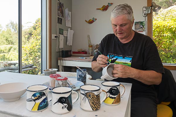
Email us your catches and you're in the monthly draw for one of these beautiful Lynda Harris native bird coffee mugs :)
Email your catches weekly or monthly to
Many thanks!
Download our safe trapping guidelines
Download our health and safety policy
| Pests removed since 1st May 2017 | Traps / bait stations in the field | Active trappers | Properties/areas being trapped |
|---|---|---|---|
| 31,936 | 2,600+ | 110+ | 250+ |
Totals to 31st March 2025
| Rats | Mice | Possums | Stoats | Weasels | Hedgehogs | Feral Cats | Rabbits | Mynas | Magpies | Total |
|---|---|---|---|---|---|---|---|---|---|---|
| 11,613 | 10,602 | 1,964 | 220 | 177 | 441 | 128 | 2,118 | 4,648 | 25 | 31,936 |
| Total breakdown | 2017 | 2018 | 2019 | 2020 | 2021 | 2022 | 2023 | 2024 | 2025 | Total | |||
|---|---|---|---|---|---|---|---|---|---|---|---|---|---|
Kerikeri Peninsula Conservation Trust (Akeake Reserve to the north side of the Rangitane Stream) |
269 | 2,315 | 3,291 | 6,414 | 3,467 | 4,048 | 4,604 | 4,496 | 726 | 29,618 | |||
| Friends of Rangitane Stream (our neighbours who trap the south side of the Rangitane Stream) |
209 | 681 | 609 | 287 | 194 | 267 | 61 | 2,318 | |||||
| Total | 269 | 2,315 | 3,500 | 7,095 | 4,074 | 4,335 | 4,798 | 4,763 | 81 | 31,936 | |||
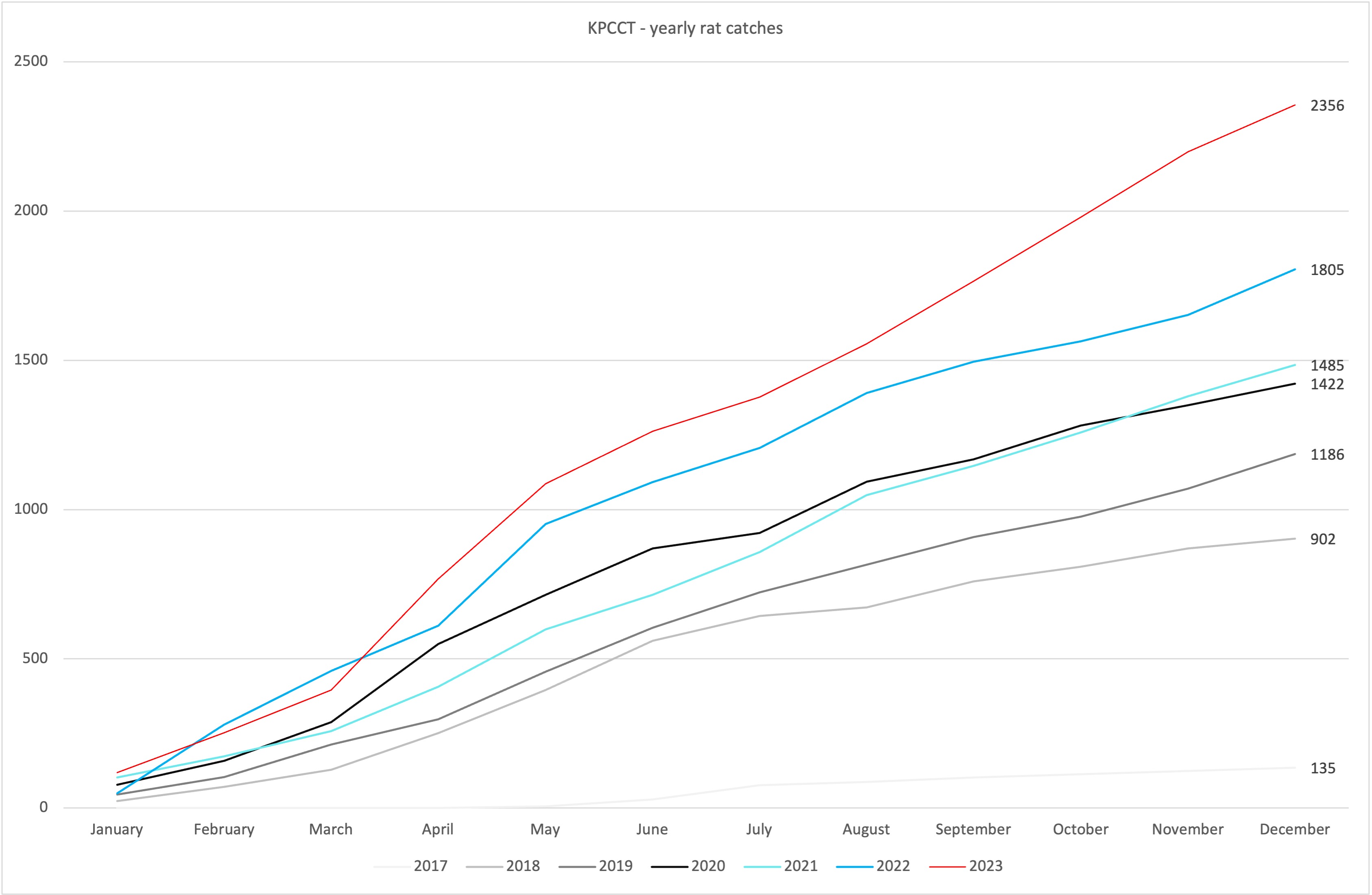
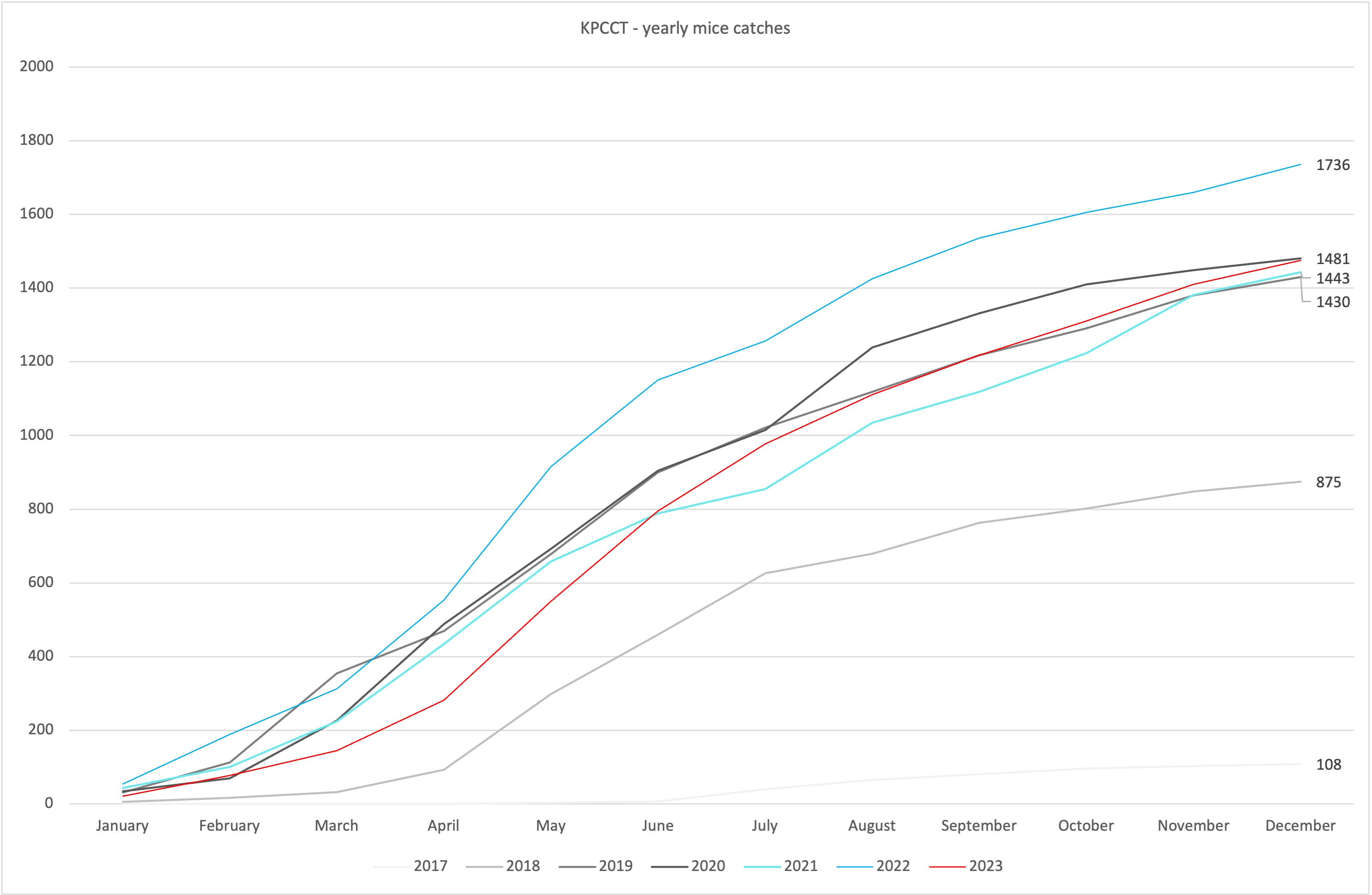
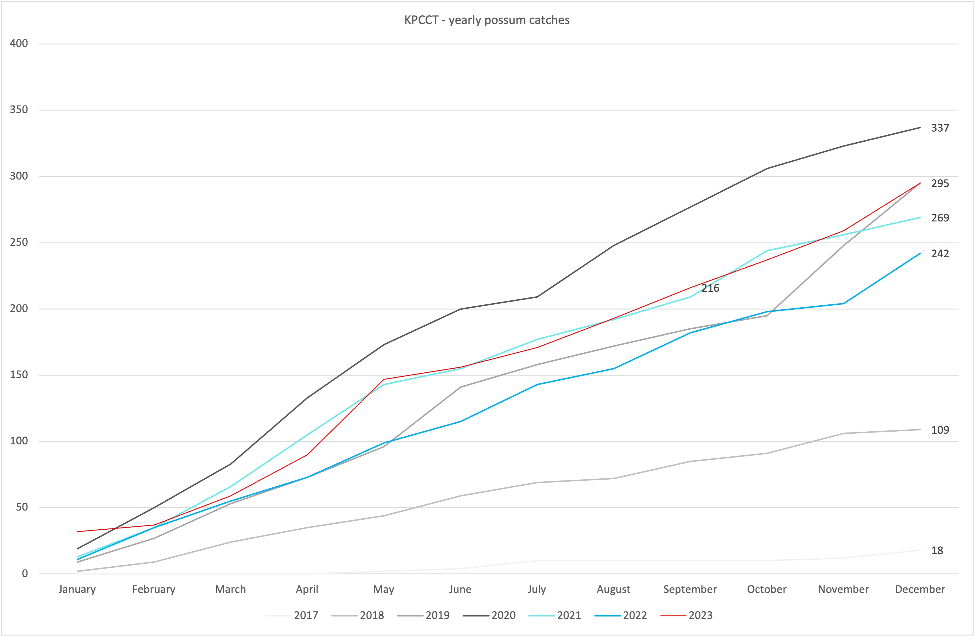
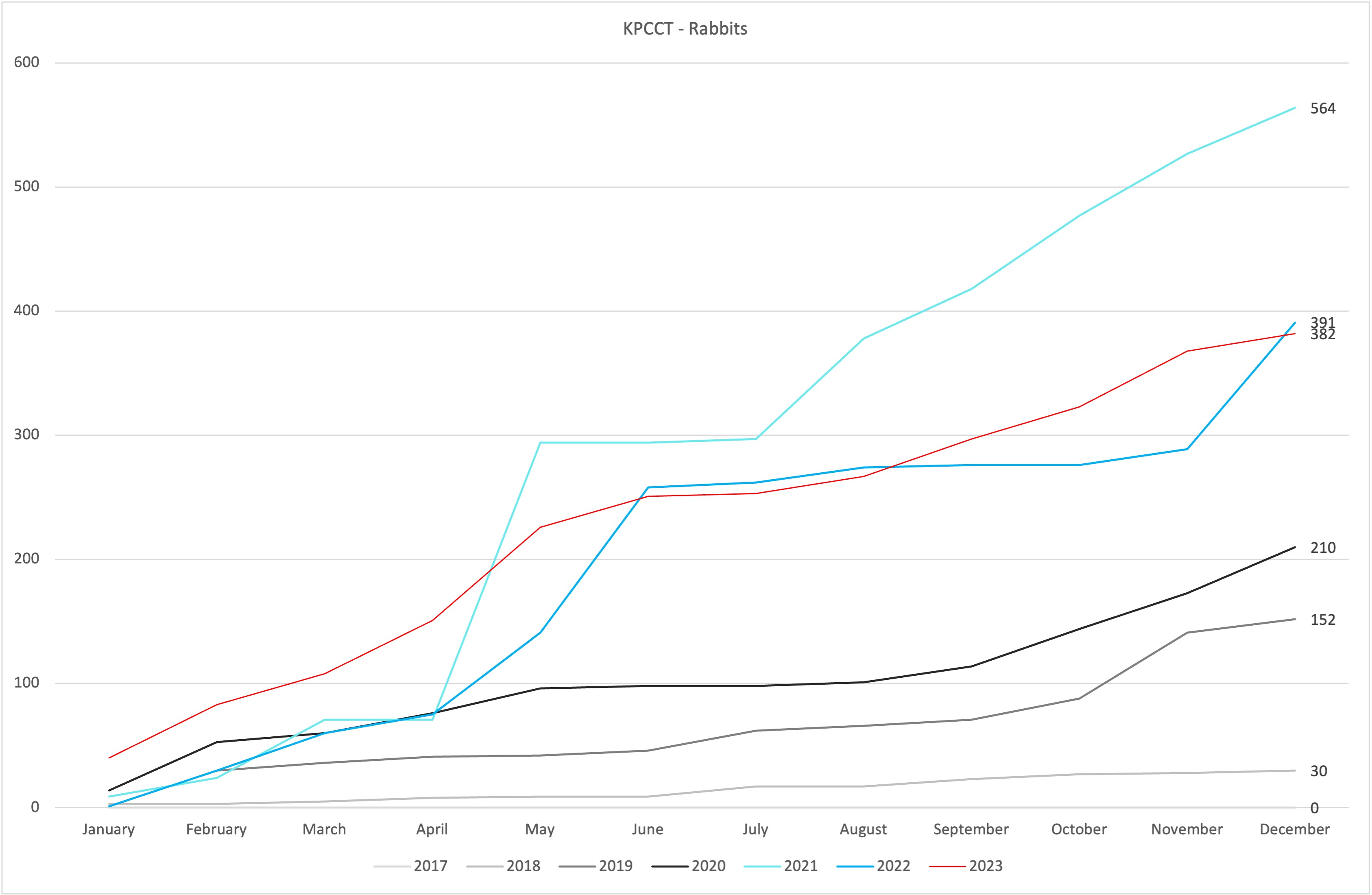
| Totals Yearly | Rats | Mice | Possums | Stoats | Weasels | Hedgehogs | Feral Cats | Rabbits | Mynas | Magpies | Total |
|---|---|---|---|---|---|---|---|---|---|---|---|
| 2025 | 347 | 194 | 82 | 12 | 11 | 13 | 1 | 91 | 33 | 3 | 787 |
| 2024 | 1,975 | 1,860 | 317 | 26 | 37 | 69 | 10 | 288 | 180 | 1 | 4,763 |
| 2023 | 2,356 | 1,475 | 295 | 25 | 29 | 67 | 23 | 391 | 133 | 4 | 4,798 |
| 2022 | 1,805 | 1,736 | 242 | 30 | 26 | 75 | 17 | 391 | 10 | 3 | 4,335 |
| 2021 | 1,485 | 1,443 | 269 | 34 | 13 | 94 | 27 | 564 | 140 | 5 | 4,074 |
| 2020 | 1,422 | 1,481 | 337 | 29 | 29 | 53 | 23 | 210 | 3,502 | 9 | 7,095 |
| 2019 | 1,186 | 1,430 | 295 | 33 | 18 | 41 | 18 | 152 | 327 | 3,500 | |
| 2018 | 902 | 875 | 109 | 30 | 14 | 23 | 9 | 30 | 323 | 2,315 | |
| 2017 | 135 | 108 | 19 | 1 | 6 | 1 | 269 |
Catches by area 1st May 2017 to 10th Jan 2025
| Area | Rats | Mice | Possums | Stoats | Weasel | Hedgehog | Feral Cat | Rabbit | Mynas | Magpies | Total |
|---|---|---|---|---|---|---|---|---|---|---|---|
| Kerikeri Peninsula Conservation Trust areas | |||||||||||
| Akeake Reserve | 158 | 1,073 | 39 | 3 | 6 | 5 | 1 | 1,285 | |||
| Opito Bay | 519 | 726 | 28 | 1 | 2 | 1 | 1 | 20 | 1,298 | ||
| Between Opito Bay - Doves Bay | 624 | 907 | 128 | 30 | 6 | 99 | 12 | 153 | 688 | 2,649 | |
|
Opito to Redcliffs - Roadside |
174 | 17 | 0 | 7 | 3 | 41 | 7 | 6 | 1 | 256 | |
| Doves Bay Marina | 62 | 212 | 274 | ||||||||
| Doves Bay | 351 | 563 | 30 | 12 | 2 | 18 | 4 | 22 | 43 | 1,045 | |
| Between Doves Bay - Rangitane | 1,413 | 1,671 | 218 | 26 | 16 | 98 | 8 | 222 | 116 | 3,788 | |
| Rangitane Reserve | 504 | 1,060 | 44 | 6 | 8 | 9 | 10 | 1 | 1,660 | ||
| Aroha Island | 300 | 451 | 155 | 14 | 5 | 1 | 2 | 46 | 1 | 975 | |
| Rangitane | 1,780 | 1,425 | 189 | 15 | 6 | 74 | 18 | 650 | 593 | 9 | 4,759 |
| Wainiu Island | 44 | 2 | 46 | ||||||||
| Redcliffs Rd/Te Kowhai Point Roadside | 383 | 27 | 23 | 12 | 46 | 41 | 12 | 1 | 2 | 547 | |
| Rangitane Rd | 723 | 545 | 52 | 2 | 2 | 1 | 223 | 51 | 1,599 | ||
| Te Kowhai Pt Rd | 210 | 29 | 100 | 11 | 15 | 1 | 1 | 8 | 4 | 1 | 380 |
| Redcliffs Rd | 1,362 | 659 | 183 | 40 | 22 | 1 | 30 | 436 | 2,746 | 13 | 5,492 |
| Matoa | 551 | 62 | 9 | 1 | 623 | ||||||
| Skudders Beach | 241 | 44 | 108 | 2 | 1 | 396 | |||||
| Rangitane stream -north side | 860 | 63 | 247 | 18 | 9 | 13 | 11 | 2 | 334 | 1,595 | |
| Roadkill removed | 1 | 19 | 4 | 1 | 3 | 33 | 61 | ||||
| Nightshooting | 5 | 1 | 8 | 1 | 160 | 175 | |||||
| 10,295 | 9,550 | 1,584 | 201 | 153 | 413 | 120 | 1,963 | 4,601 | 23 | 28,903 | |
| Friends of Rangitane Stream areas | |||||||||||
| Rangitane Stream south side - lower | 623 | 765 | 222 | 5 | 8 | 12 | 3 | 59 | 13 | 1,710 | |
| Rangitane Stream south side - upper | 332 | 109 | 68 | 2 | 4 | 3 | 4 | 8 | 2 | 532 | |
| Skuuders Beach | 54 | 18 | 12 | 1 | 85 | ||||||
| 1,009 | 892 | 302 | 7 | 13 | 15 | 7 | 67 | 15 | 2,327 | ||
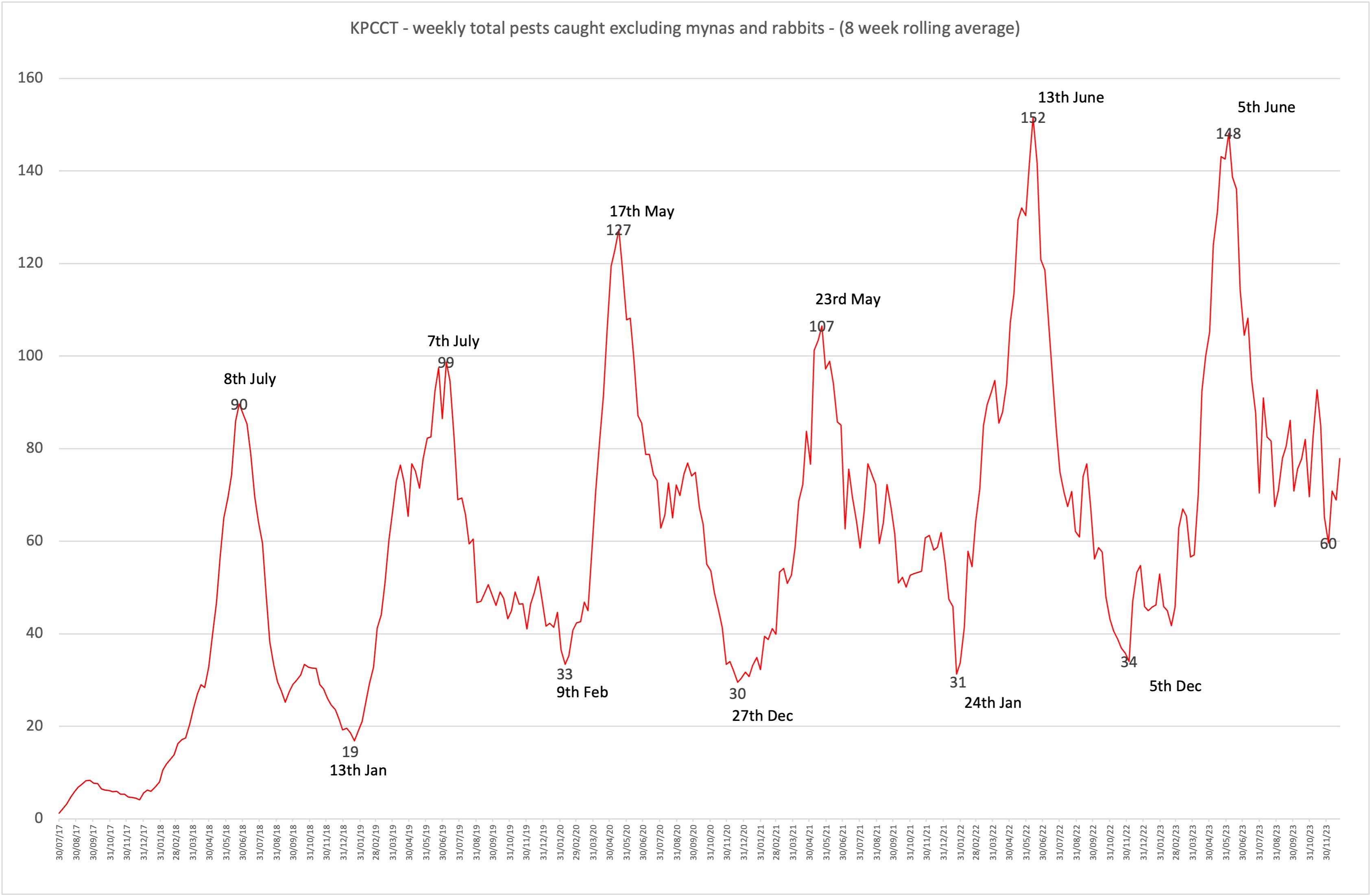
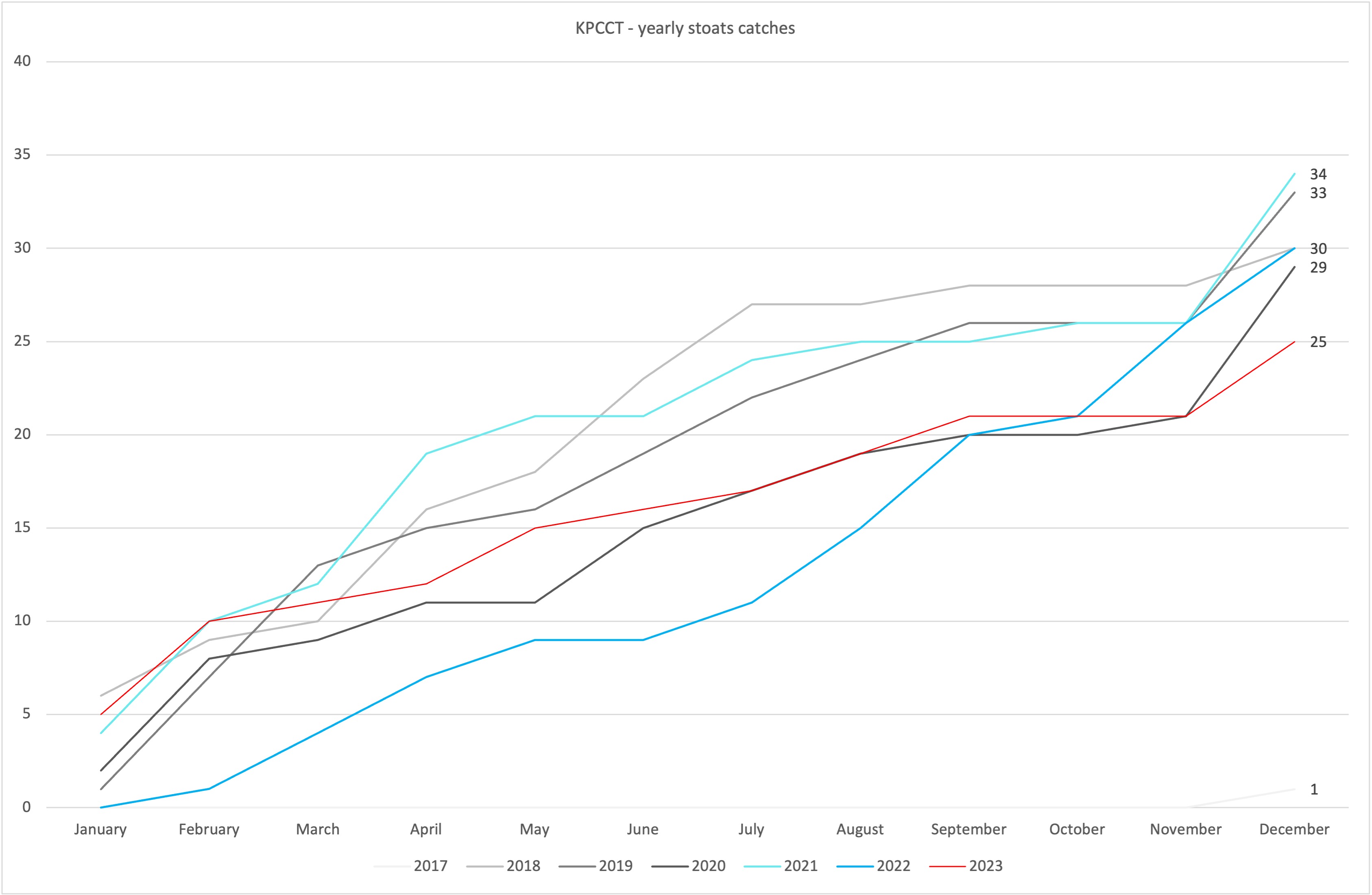
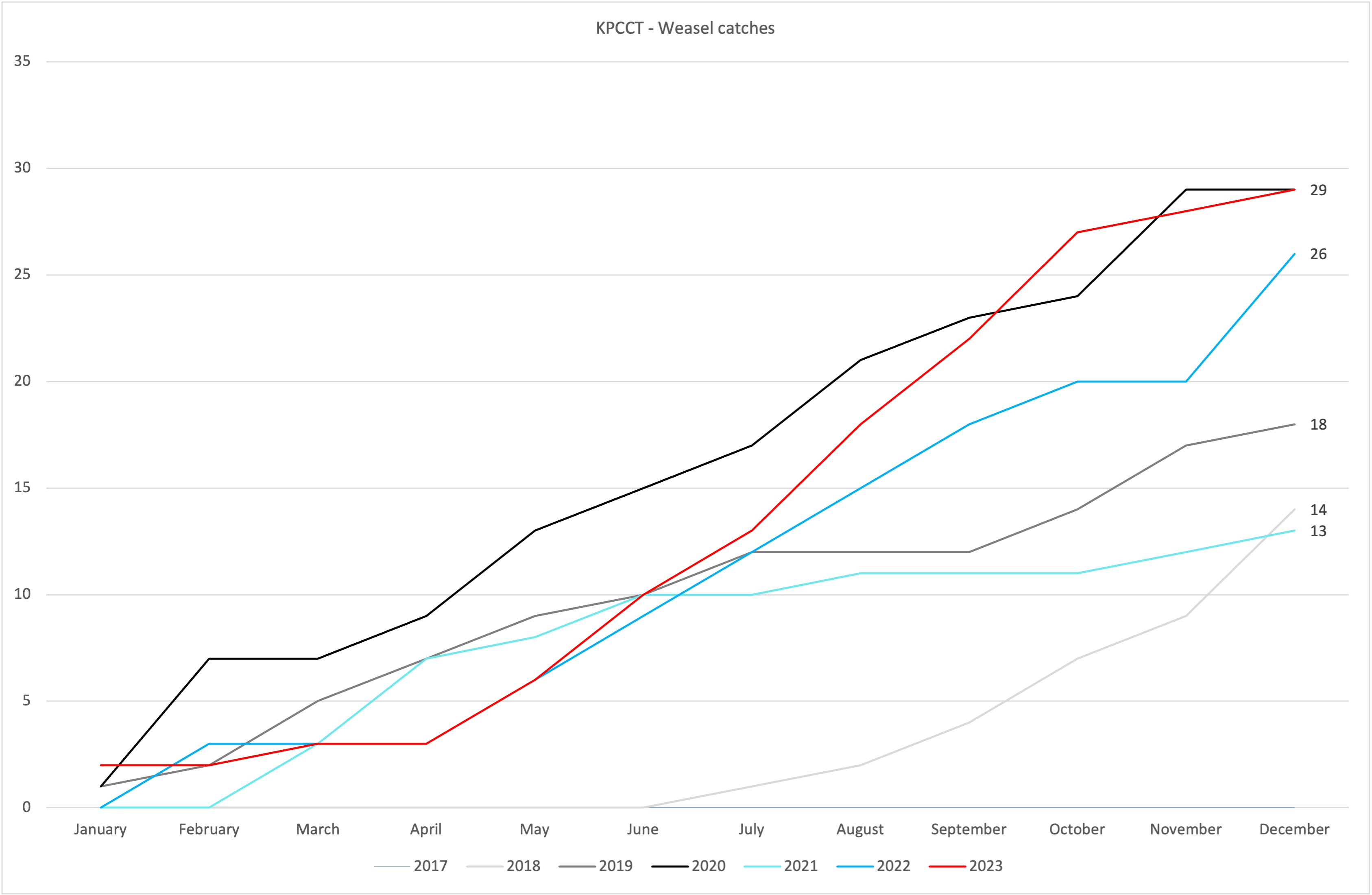
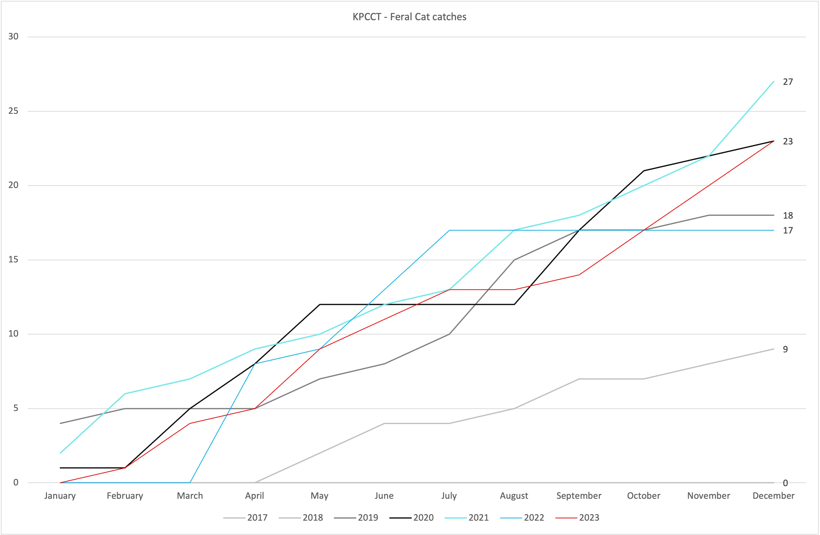
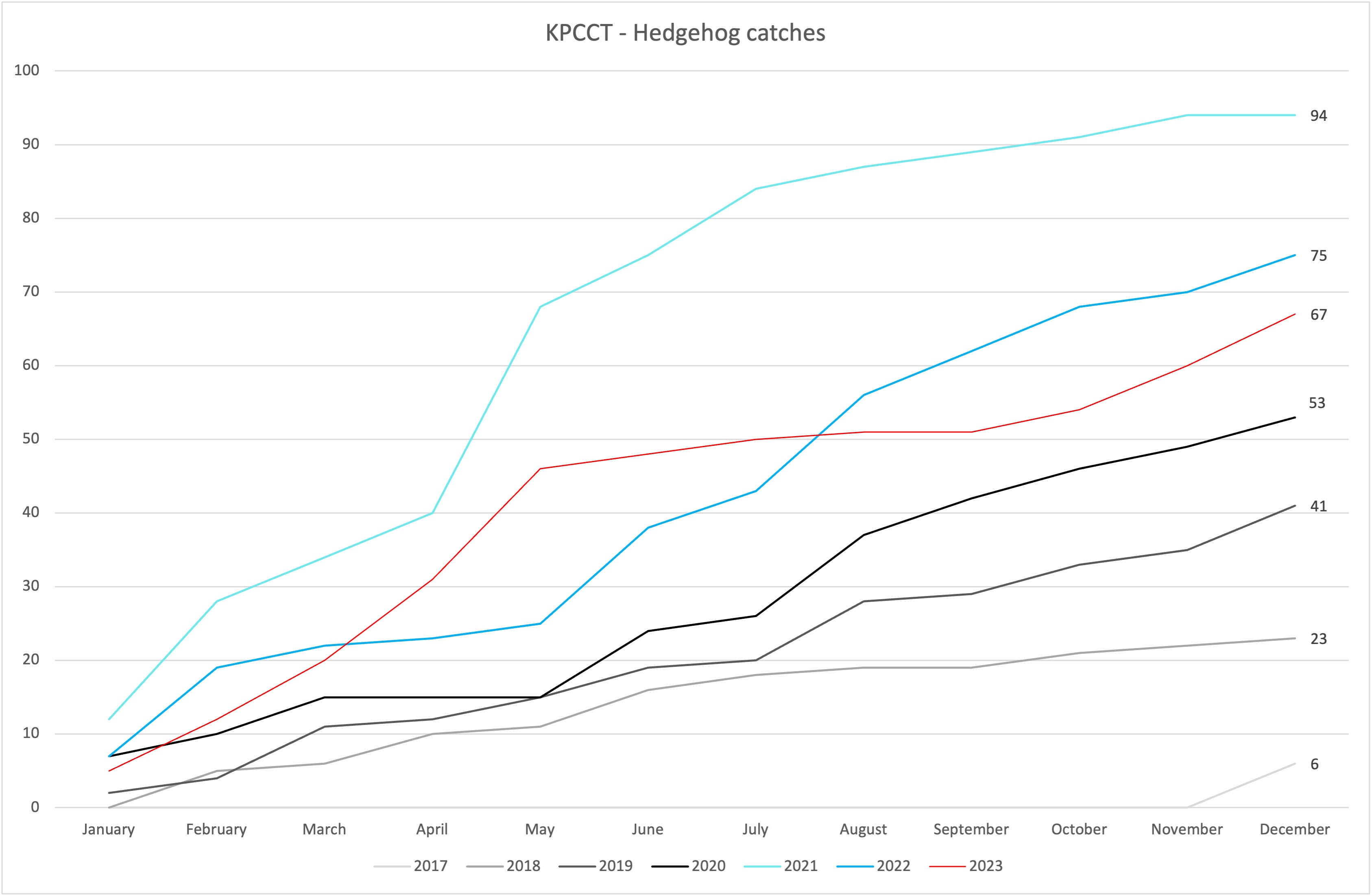
Catch graphs updated 10th January 2024